Your guide to hiking in Lofoten
Your guide to hiking in Lofoten
Håen (Håheia) 438m
Medium
About This Hike – A Short Introduction
Håen (also called Håheia) is a 438-meter peak on the island of Værøy, known for offering one of the most breathtaking viewpoints in the Lofoten Islands. The hike is relatively short, around 5–6 km round trip, and takes approximately 2–3 hours to complete. The trail follows an old military access road, making it a gentle and easy walk, suitable for most hikers, including families. Despite the moderate effort required, the reward at the summit is spectacular. From the top, you’ll enjoy a panoramic view of the dramatic cliffs, turquoise waters, and white sandy beaches that make Værøy such a unique destination. This is a must-do hike when visiting the island, offering unparalleled views without a challenging climb.
Getting There & Parking – How to Get There and Where to Park
Værøy is accessible only by ferry or air. You can take a ferry from Bodø on the mainland or from Moskenes in Lofoten. Another option is to fly by helicopter from Bodø to the small airport on Værøy. The ferry arrives near Sørland, the island’s main village, from where you can drive or walk north to the start of the trail.
The parking area for the hike is located in Rømdalen, just north of Sørland, at the end of the valley. To reach it, follow the road north from the ferry terminal, passing through the village and continuing toward Rømdalen. The parking area is easy to recognize as it is located next to some distinctive blue buildings at the top of the valley. The old NATO road leading up Håen is closed to public vehicles, so you must park here and begin the hike from this point.
Click here to find the parking lot on Google Maps.
Trailhead – How to Find the Start of the Hike
The trailhead for Håen is located next to the parking area in Rømdalen. Look for a signposted trail on the left side of the blue building—this is where the hike begins. The path is well-trodden and easy to follow, heading uphill toward the old NATO road visible in the distance. From here, simply follow the obvious trail upward, which will lead you to the summit of Håen.
Hike Overview – What to Expect on the Hike
The hike to Håen (Håheia) is an easy and scenic route that offers breathtaking views throughout the ascent. From the parking area in Rømdalen, the trail begins as a clear footpath that climbs steadily up the grassy hillside. As you ascend, the path crosses the old military road a few times via switchbacks, providing increasingly beautiful views of Sørland, the village and harbor below. The initial ascent is moderate, making it accessible for most hikers, and the trail remains well-trodden and easy to follow.
After around 20–30 minutes of hiking, the footpath merges with the old NATO road at a large bend in the trail, approximately 160 meters above sea level. From this point onward, the remaining 2 kilometers to the summit follow a gentle incline along the paved military road, making for a comfortable and scenic walk.
On the way up the mountain, you will pass small stone huts near the road. These structures, known as ørnhus (eagle houses), were historically used by locals to capture sea eagles by hand, offering a fascinating glimpse into Værøy’s past.
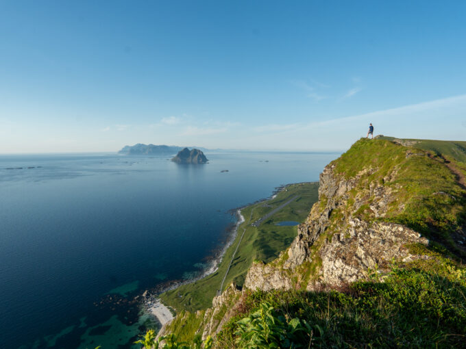
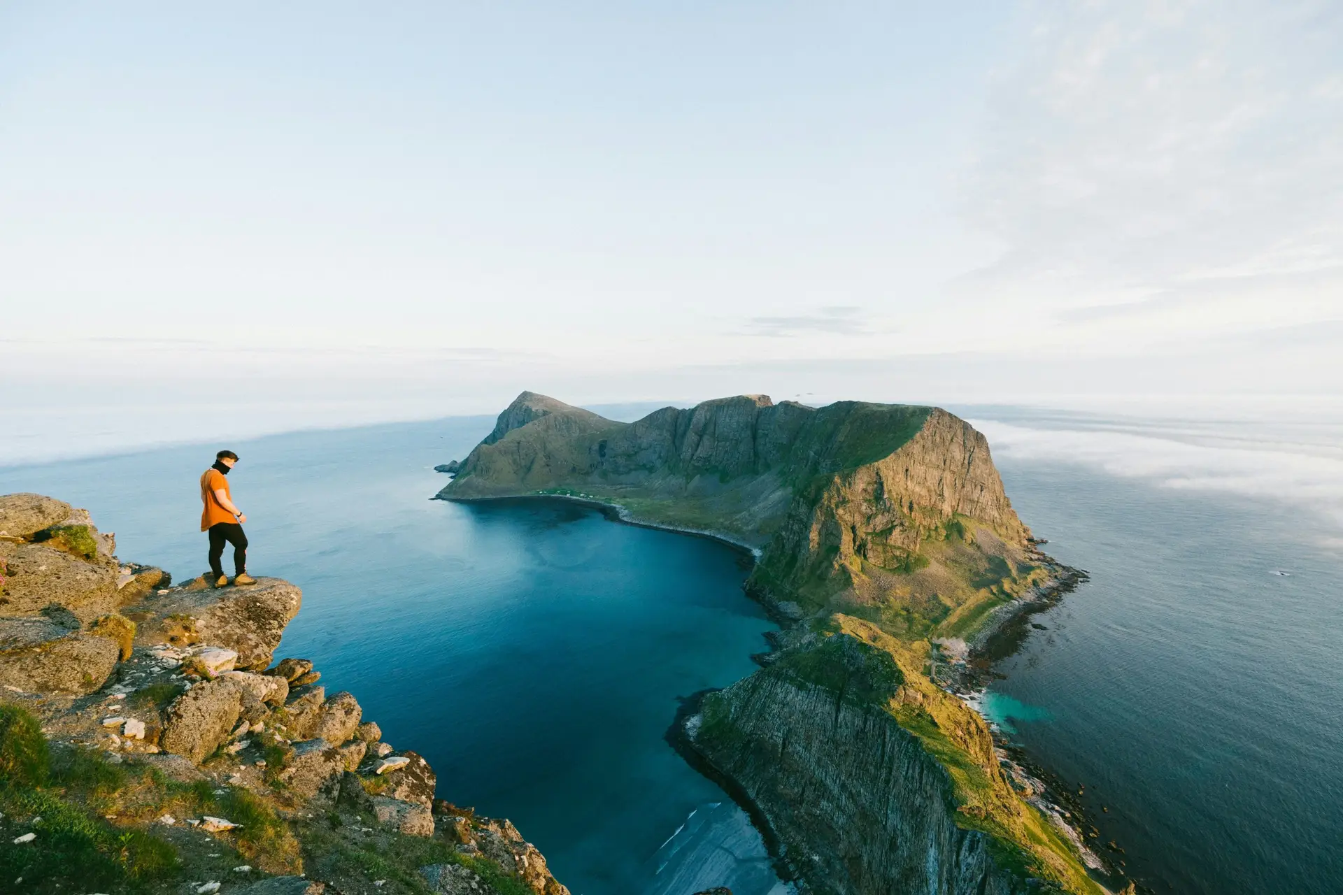
As you approach the top, the white radar dome of the old NATO installation comes into view, marking the final stretch of the hike. Walking past the radar station, you will soon reach the viewpoint at 438 meters, where a stunning panoramic vista unfolds before you. The view from Håen is nothing short of spectacular—to the west, the sheer cliffs drop dramatically into the remote bay of Måstad, with its hidden white-sand beach nestled far below. The jagged peaks of Måstadfjellet rise steeply around the bay, creating a breathtaking contrast against the turquoise waters of the Norwegian Sea. Looking in other directions, you can see the entire island of Værøy, the surrounding ocean, and, on especially clear days, even the distant Norwegian mainland.
While enjoying the view, it’s important to exercise caution near the cliffs, as the drop-offs are extremely steep. If hiking with children, keep a safe distance from the edges and remain on stable ground.
With its relatively easy trail, incredible viewpoints, and fascinating history, Håen is a must-do hike on Værøy. It perfectly captures the wild beauty of the Lofoten Islands and provides one of the most spectacular viewpoints in all of Norway. Whether you’re visiting Værøy for a short stay or spending several days exploring the island, this accessible and rewarding hike is one of the best ways to experience Lofoten’s rugged landscapes.
Hike Map – GPX Route and Elevation Profile
Weather Forecast – Check the Weather Before You Hike

GPX Note
Please note that the GPX files provided are not 100% precise. They should be used as a general reference for guidance and not as the sole source of navigation. Always ensure to stay aware of your surroundings to ensure your safety while hiking.